|
Click to download walk |
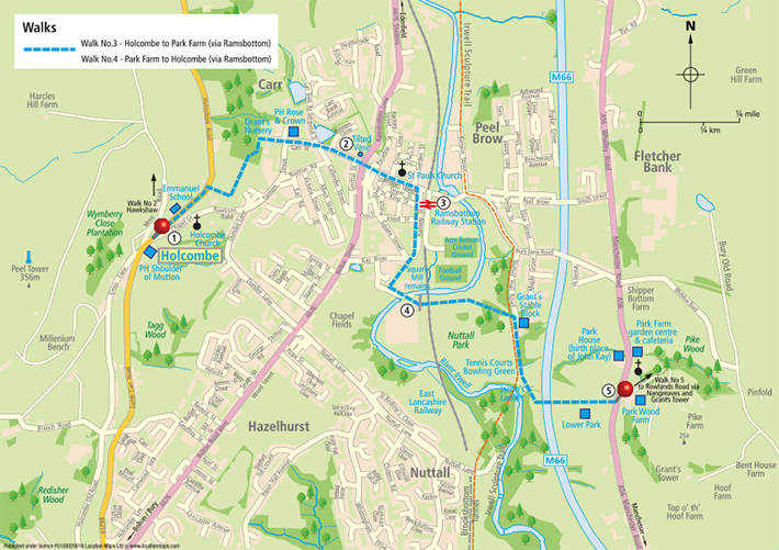
From Park Farm Garden Centre and Cafe cross Bury New Rd, turn left and then first right down the cobbled lane, signposted ‘Nuttall Hall Rd 800 yds.’
|
| Across the field to the right you will see Park Farm, where John Kay, the inventor of the ‘flying shuttle’ which revolutionised the textile industry in the 18th century, was born in 1704. His father was a yeoman farmer who then owned the Park Estate. He invented the’ flying shuttle’ aged 26, which halved the labour required to operate a loom. Due to a combination of the resistance of the weavers to use it and the abuse of his patent rights on the shuttle by other manufacturers, and, despite inventing many other improvements, he sadly died in Paris in 1779 a penniless and forgotten man. |
 Cross the front of Lower Park House, go over the stile and across the meadow down to the pedestrian footbridge over the M66 motorway, Cross the front of Lower Park House, go over the stile and across the meadow down to the pedestrian footbridge over the M66 motorway,
|
| Crossing the meadow there are spectacular views ahead of Holcombe Hill and Peel Tower. It’s worth pausing for a moment as you cross the bridge to reflect on the calm and timelessness of the landscape all around and the non-stop noise, speed, and endless urgency of the traffic passing beneath it. |
Cross Bury New Rd and down the cobbled lane opposite, signposted ‘Nuttall Hall Rd 800 yds.’
From the bridge follow the path downhill to the left and down the long flight of steps known as ‘Jacob’s Ladder’. |
| Now largely forgotten and unknown but once a renowned beauty spot where people, in days before television and the internet, came from far and wide to see the gorge, clearly seen on your right as you go down the steps, and its waterfall which is most impressive for days after heavy rain. The ladder may have derived its name from the fact that for many years it’s was the route the congregation went up to worship at Park Chapel above. |
| Turn right up Nuttall Hall Rd (Irwell Nature Trail) as far as the old stable block with the crest of the Grant Family above the front door. |
| The park, Nuttall Hall and the cost of installing all the existing features and facilities were donated to the town in 1928 by a local mill owner and philanthropist Lt Colonel Austin Porrit for the health and welfare of its residents. The park was purchased originally in1812 and developed by the John Grant who built the hall as a family home in 1817, together with stable blocks and outbuildings, which still survive to this day. The hall was demolished by the council in 1952. |
  Where you have a choice to either:- Where you have a choice to either:-
a, Turn left across the car park via the children’s playground, tennis court, bowling greens and public toilets (open at weekends) to the far right hand corner of the park
or
b, Proceed along the road taking a left turn just beyond the front of the old stable block signposted “Bolton St 800 yds” (closed to vehicles by 6 permanent bollards). This path eventually comes out by the River Irwell and joins the alternative path across the park at the entrance to the foot tunnel beneath the ELR railway line.
Continue through the pedestrian underpass.
| Note on the opposite bank the original stone foundations of the famous Square Mill, in its day the largest dyeing and bleaching mill in Europe if not the world. Built by the Grants in 1821 and because of industrial unrest prevailing at the time, it was moated like some medieval castle, with only a drawbridge to get in or out of the mill. In the river below the foundations there are plenty of brown and rainbow trout. |
|
Cross the river bridge ahead following the road around to the right. Continue straight ahead into Railway St passing the Aldi Supermarket on the left as far as its junction with Bridge St.
 The railway station, level crossing and signal box are on the right and the Railway Hotel on the left. The railway station, level crossing and signal box are on the right and the Railway Hotel on the left. |
| After the formal closure of the line in 1982 it reopened in 1987 as the East Lancashire Railway, run by volunteers. It is 12 miles long, and runs trains (some steam) between Rawtenstall and Heywood, every weekend, all year round. The signal box was built in 1939 and is one of the last manually controlled main road crossing in the country. ELR have ambitious plans to extend the line and number of stations in the future and successfully run and organise events varying from War Weekends to Santa Specials throughout the year. |
 Turn left up Bridge Street and into Ramsbottom town centre. Turn left up Bridge Street and into Ramsbottom town centre.
| Ramsbottom (a name straight from the music hall) is largely a 19th century creation and a good example of a Pennine Textile town. Since the decline of its textile roots it has successfully transformed itself by being granted conservation status in1977 and the arrival of the East Lancs Railway in 1987 has made the town a popular tourist destination. Bolton and Bridge streets have retained many of their original features as does the Market Square at the heart of the town which hosts a farmers’ market monthly and is surrounded by good restaurants and an interesting selection of shops. The town was voted by the Daily Telegraph in Dec 2013 to be the runner up in a national competition to find the most attractive high street in the land. |
 Having explored all the delights that Ramsbottom has to offer by day (and perhaps by night) at the traffic lights proceed up Carr St past the Library. Having explored all the delights that Ramsbottom has to offer by day (and perhaps by night) at the traffic lights proceed up Carr St past the Library.
At the Rose and Crown do not bear left but go straight ahead up the steeply cobbled Manor Street for approximately 40 yards before turning left at the footpath sign below the entrance to the ‘Manor House’.
Follow the narrow path up and around the house to the wooden gate at the entrance, to mature woodland known locally as Grant’s Nursery.
Go through the gate and head up hill in a diagonal direction to the far side of the wood looking out for way-marker posts and the solitary gate post that marks the continuation of the path on the far side of the wood.
Leaving Grant’s Nursery behind, follow the path up the hill through what is now a youthful, but will one day will be handsome woodland of mainly oak trees, to arrive at the final flight of stone steps and up on to Helmshore Rd.
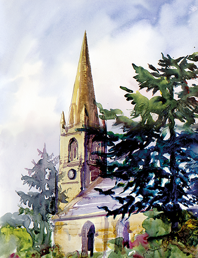
 Turning left for Holcombe you will just see the spire of Emmanuel Church above the trees to the left and the Georgian façade of the Shoulder of Mutton in the distance at the heart of the village. The village school is on the right hand side Turning left for Holcombe you will just see the spire of Emmanuel Church above the trees to the left and the Georgian façade of the Shoulder of Mutton in the distance at the heart of the village. The village school is on the right hand side
|
| The village school, which opened in 1864 was built by stone quarried locally and free labour. The school bell on the roof is inscribed Richard Fletcher, Warden,1698 and came from the old Holcombe Tudor Chapel of Ease. Look carefully for the shrapnel marks on the stone work on the right hand corner as a result of the only bombing raid on Holcombe when in Sept 1916 a Zeppelin appeared in the night sky and dropped 5 bombs. Another bomb badly damaged the Post Office directly across the road from the Shoulder car park. The only casualty in the village was a thrush, which was stuffed and mounted in a glass case, with its feet in the air just as it was found and given an official First World War memorial number and has been kept in the school ever since. |
| As you near the heart of the village you become aware of Peel Tower on the hill above standing there as it has for the past 160 years and the welcoming sight of the 18th century Shoulder of Mutton. |
 |
| BACK TO TOP |
| |
| |
| |
|
|